I have found this iPhone App to be invaluable on our walks. For our most recent Caminos, I have pre-loaded the maps for the area where we will be walking as well as the tracks for the Camino. That way, we can wander off trail whenever we want to – or, more likely, when we accidentally do – and we can easily find our way back to the Camino. The app shows all roads as well as existing walking trails. I have been amazed at how they can map the tiniest of footpaths. Whenever trail markers are confusing or sparse, this app works as a backup to make sure we stay on trail. It works in airplane mode too so that we don’t need to spend anything on mobile data. When not in range of cellphone towers, it determines our position by satellite. We cannot get lost when we use maps.me. I believe the app is also available for Android phones and I have to assume that the instructions for usage are somewhat similar.
Install maps.me
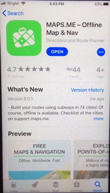
Go to your iPhone’s App Store and search for maps.me. It should look like this:
Press the Get / Install button.
Once installed, you can open maps.me. Do not allow it to send you any notifications.
Go to your iPhone Settings App. Choose “Privacy” “Location Services”. Look for maps.me and choose to activate location services “While Using the App”.
Find the GPS tracks of your intended walk.
I usually find these from the website Wikiloc but they can be found anywhere. For example, the most up-to-date tracks for the Camino Ignaciano are on that organization’s own website, e.g.: Caminoignaciano.org
If you find your trail in Wikiloc while using your phone, download the Google Earth version of the tracks (.kml or .kmz extensions).
After it is downloaded, it should ask if you want to open it in maps.me. Tap on that option.
Once the bookmarks are loaded, you should see the trail in maps.me.
Now you can zoom in on the trail and download the maps for that area. Make sure you download the maps for the whole length of the trail that you need.


If you use your PC to find the tracks, I usually open them in Google Earth first. This allows me to manipulate and personalize them some to get rid of everything except the trails themselves. Some people like to add pins, names, or other data to their trails.
If you use the Google Earth / PC method, after you have opened all the downloaded files, make sure that you save them to “My Places” under a single folder. You can create that folder in Google Earth and name it something like “Camino Frances”.
You will now have to transfer the kml files to your iPhone. You can do this easily if you have a gmail account. Just go to the folder in Google Earth where you saved all your track files, right click on the folder and choose “Email…”. Sign into your gmail account when prompted. You will then have to go back to the Google Earth folder again, right-click again and choose “Email…” again. This time, send the message to yourself.
If you don’t have a gmail account, in Google Earth right-click on the folder where you saved all the gps trails that you want; choose [Save Place As…]; then save the kmz file to a place where you will have to then e-mail or transfer it to your phone.
Now go to your iPhone, open the message, press and hold the kmz attached file for two seconds, then tell the phone to open the file in maps.me.
Make sure to download the maps for the area as noted above.
___________________________________________________________________________
Note that occasionally you may only be able to find GPS tracks in the format for something other than maps.me / Google Earth. If they are not kmz or kml file extensions and these other files are the best and most recent that you can find, you can use the internet to convert the files for you. A good app that converts them for you is GPSBabel. Alternatively, this website can convert files for you: GPS Visualizer.There used to be some on-line programs that could do it for you be I cannot find a good one anymore.
You can always delete the downloaded maps and trails and reload them again later. Don’t let your phone’s memory get too full with all your Caminos!
Good luck! Holler if you have questions, corrections or suggested edits.
