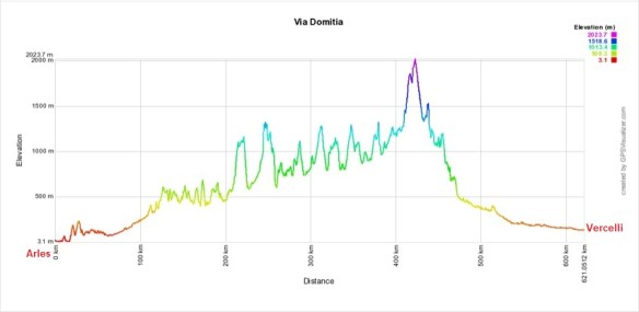
Our September – October 2019 Camino from Vercelli, Italy to Montpellier, France along the ancient, pre-Roman trail connecting northern Italy and southern France over the French Alps. From Vercelli, we will be passing through Turin, Montgenèvre, Briançon, Embrun, Gap, Sisteron, Apt, and Arles before returning to Montpellier.
This route is the final link, connecting several of our previous walks covering every step (except 8km!) between Lisbon, Santiago de Compostela, St. Jean Pied de Port, Montpellier, Vercelli and Rome.
After the walk
Thoughts and reflections after the walk
Our trail – Closer to the Via Domitia than the GR653d
Before the walk
It just got real
T minus seven hours and counting
Back in the land of tiny showers
Day by day on the walk
Day 0 – Vercelli to Salasco, 20.0km, 6.75hrs
Day 1 – Salasco to Lamporo, 25.7km, 7.5hrs
Day 2 – Lamporo to Chivasso, 21.3km, 6.25hrs
Day 3 – Chivasso to Turin, 29.0km, 8.5hrs
Day 3.5 – Playing tourist in Turin
Day 4 – Turin to Avigliana, 22.1km, 6.5hrs
Day 5 – Avigliana to Bussoleno, 25.2km, 7.5hrs
Day 6 – Bussoleno to Exilles, 21.8km, 7.25hrs
Day 7 – Exilles to Cesana Torinese, 26.3km, 8.50 hrs
Day 8 – Cesana Torinese to Briançon, 18.2km, 6.5hrs (4.75hrs moving)
Day 9 – Briançon to L’Argentière-la-Bessee, 16.4km, 4.75hrs (3.25hrs moving)
Day 10 – L’Argentière-la-Bessee to Mont-Dauphin, 17.7km, 5.0hrs (4.0hrs moving)
Day 11 – Mont-Dauphin to Embrun, 19.5km, 5.0hrs (4.5hrs moving)
Day 12 – Embrun to Chorges, 26.7km, 7.75hrs (6.5hrs moving)
Day 13 – Chorges to Gap, 18.0km, 4.75hrs (4.25hrs moving)
Day 14 – Gap to Tallard Airport, 20.0km, 6.0hrs (5.0 hrs moving)
Day 15 – Tallard Airport to Thèze, 22.2km, 5.0hrs (4.5hrs moving)
Day 16 – Thèze to Les Bons Enfants, 22.4km, 7.0hrs (5.0hrs moving)
Day 17 – Les Bons Enfants to Lurs, 27.6km, 8.25hrs (6.25hrs moving)
Day 18 – Lurs to Mane, 16.9km, 5.75hrs (4.25hrs moving)
Day 19 – Mane to Céreste, 24.8km, 7.75hrs (6.0hrs moving)
Day 20 – Céreste to Apt, 20.8km, 6.0hrs (4.75hrs moving)
Day 21 – Apt to Coustellet, 25.3km, 7.25hrs (5.75hrs moving)
Day 22 – Coustellet to Eygalières, 26.6km, 7.25hrs (6hrs moving)
Day 23 – Eygalières to Saint Étienne-du-Grès, 23.8km, 7.0hrs (5.5hrs moving)
Day 24 – Saint-Étienne-du-Grès to Arles, 23.8km, 7.25hrs (5.5hrs moving)
Day 24.5 – Playing tourist in Arles
Day 25 – Arles to Saint-Gilles, 22.0km, 6.25hrs (5.0hrs moving)
Day 26 – Saint-Gilles to Vauvert, 20.6km, 5.5hrs (4.75hrs moving)
Day 27 – Vauvert to Saint-Christol, 23.6km, 7.25hrs (5.75hrs moving)
Day 28 – Saint-Christol to Montpellier, 27.0km (+1.2km to hotel), 7.75hrs (6.5hrs moving)
NOTE: The Via Domitia was our intended route to follow. It turns out that the GR653d is a more mountainous adaptation of the Via Domitia that goes through or near the main cities of the original Roman road but connecting them with trails that add considerable mileage, excessive elevation changes and sometimes hazardous paths. After seeing first hand some of the challenges, we have decided to walk our own route, closer to the original Via Domitia (now mostly buried under a highway). We look to walk offroad as much as reasonably possible but we don’t make excessive detours to visit newer sites or just to add altitude.
Click here for a zoomable map of our intended route.