As noted in our blog, we often strayed from the GR653d route. I’m guess that we were on the marked trail only about 75% to 80% of the total distance. Why? Because we had trouble finding accommodations in some places, some distances between beds were too long for us, finding food was somewhat high on our needs, some trails were overly difficult or excessively mountainous for us. I recommend that if you are walking this trail, you should have a smartphone based off-line GPS app, pre-loaded with several versions of this trail to give you options. I like maps.me but use whatever you like.
Our GPS tracks can be downloaded from Wikiloks HERE.
Or, directly as a zipped file HERE
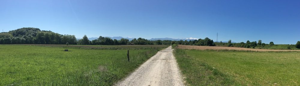
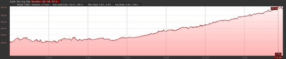
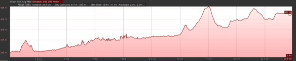
Day 0 – Vercelli to Salasco Distance: 20.0km Time: 6.75hrs (4.25hrs moving)
Elevation gain: 41m Elevation loss: 8m
Alternative route to avoid walking down a major road all the way to Lamporo; not marked so you need GPS; flat among the farms, there is a Decathlon near the route; need to get to Salasco by 3:15 to catch the bus back to Vercelli; you have to tell the bus driver when you want to come down; no place to stay in Salasco; nice ostello in Vercelli; look for pilgrims coming down the Via Francigena
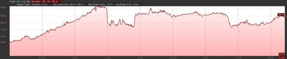
Day 1 – Salasco to Lamporo Distance: 25.7km Time: 7.5hrs (6.0hrs moving)
Elevation gain: 45m Elevation loss: 25m

Still on alternative route; flat; farms; nice ostello; need GPS; some places we needed to bash through small sections of overgrown trails but 75% off-road
Day 2 – Lamporo to Chivasso Distance: 21.3km Time: 6.25hrs (5.0hrs moving)
Elevation gain: 70m Elevation loss: 46m
A fair amount of trail marking but still suggest having GPS as a backup; still flat; 2/3s off-road with blacktop only 1-2 km per section
Day 3 – Chivasso to Turin Distance: 29.0km Time: 8.5hrs (6.35hrs moving)
Elevation gain: 140m Elevation loss: 62m

As always, walking into a big towns is not great but this wasn’t too bad; we went off trail and took the canal route which I reckon was shorter, flatter, possibly illegal and sometimes too overgrown but likely better than the marked route; still flat
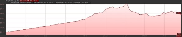
Day 4 – Turin to Avigliana Distance: 22.1km Time: 6.5hrs (4.5hrs moving)
Elevation gain: 197m Elevation loss: 115m
All road, mostly straight with a slow, steady minor elevation gain except for a short steep climb in Rivoli; a cool abbey; the first view of the coming mountains
Day 5 – Avigliana to Bussoleno Distance: 25.2km Time: 7.5hrs (5.5hrs moving)
Elevation gain: 236m Elevation loss: 160m
Still all roads; still slightly uphill but barely noticeable; we chose not to do the 500m climb to San Michele and add 2.6km to the day as we weren’t really in shape for that yet; the trail around the mountain is lovely without cars
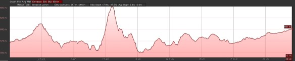
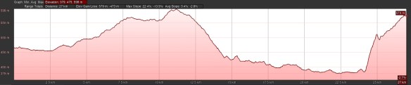
Day 6 – Bussoleno to Exilles Distance: 21.8km Time: 7.25hrs (5.5hrs moving)
Elevation gain: 692m Elevation loss: 287m

First half is mostly quiet road walking, We are climbing now; the 250m climb out of Susa is tough; you have to ignore a “do not enter” sign on a gate after the arch; we should have done more stairs before coming here
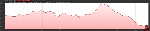
Day 7 – Exilles to Cesana Torinese Distance: 26.3km Time: 8.25 hrs (6.5hrs moving)
Elevation gain: 941m Elevation loss: 465m

Woah; nice trail but view doesn’t change with switchback after switchback; slow going on rough terrain; we had to bail out and take the road from Oulx to Cessana
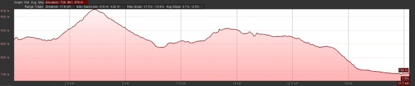
Day 8 – Cesana Torinese to Briançon Distance: 18.2km Time: 6.5hrs (4.75hrs moving)
Elevation gain: 641m Elevation loss: 756m

Take the marked San Gervasio Gorge route, not the zig-zag road walk over the mountain and thank me later; it was still balmy when we went over the top on 30 September but there was plenty of snow on the ground when we passed nearby four weeks later; gorgeous trails and views
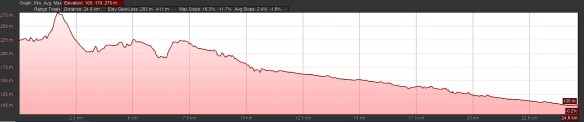
Day 9 – Briançon to L’Argentière Distance: 16.4km Time: 4.75hrs (3.25hrs moving)
Elevation gain: 204m Elevation loss: 412m

Here is where we started to seriously go off the GR route and closer to the Via Domitia; we completely bypassed Les Vigneaux as the trail sounded awful and it went so far from the Via Domitia; we loved our flatter, more direct trail but wished we could have found a better last 5km; do not follow our trail behind that stupid alpinist statue near L’Argentière – we never could find any trail and the descent back to the road is very difficult.
Day 10 – L’Argentière to Mont-Dauphin Distance: 17.7km Time: 5.0hrs (4.0hrs moving)
Elevation gain: 64m Elevation loss: 127m

Our route was definitely off the GR trail but on excellent trails near the river; avoided mountainous trails; mostly shaded and off-road; great alternative, imho
Day 11 – Mont-Dauphin to Embrun Distance: 19.5km Time: 5.0hrs (4.5hrs moving)
Elevation gain: 330m Elevation loss: 350m
GR trail until Saint-Clement; boring 6km along a boring busy road but otherwise nice and less difficult
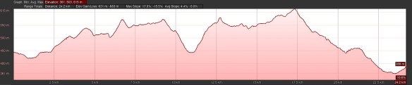
Day 12 – Embrun to Chorges Distance: 26.7km Time: 7.75hrs (6.5hrs moving)
Elevation gain: 647m Elevation loss: 651m
Off the GR route to Savines-le-Lac; very good trail along the lake but we missed the Abbey at Boscodon because we could not find accommodations for the next day if we stopped at Savines today; from Savines-le-Lac we had a tough but beautiful climb along the GR marking to Chorges where we stayed in an excellent B&B; the B&B host picked us up from the tourist office and returned us there the next day – he is a Via Domitia aficionado and we only learned too late that he could have picked us up from Montgardin
Day 13 – Chorges to Gap Distance: 18.0km Time: 4.75hrs (4.25hrs moving)
Elevation gain: 217m Elevation loss: 335m
Completely off the GR trail; our route was almost entirely on very quiet back roads and farm tracks with about an equal mix of each but we missed Notre-Dame du Laus and its “steep and dangerous GR track”; the GR trail could have saved us some city walking in Gap
Day 14 – Gap to Tallard Airport Distance: 20.0km Time: 6.0hrs (5.0 hrs moving)
Elevation gain: 383m Elevation loss: 524m
Mostly on the GR trail although we took a more direct route out of Gap and at the end, we had to go to Tallard Airport rather than Tallard to find accommodations. Some tough trails but definitely a nice way.
Day 15 – Tallard Airport to Thèze Distance: 22.2km Time: 5.0hrs (4.5hrs moving)
Elevation gain: 278m Elevation loss: 310m
We could not find any accommodation at all near La-Motte-du-Caire or anywhere near it; we could not even find anything between Tallard and Sisteron so we had two days of quiet road walking and the need to take a very expensive taxi to Thèze two mornings in a row; we were stuck with this option and would have preferred to go through La-Motte-du-Caire; the road walk on a Sunday morning was perfectly fine with very few cars.
Day 16 – Thèze to Les Bons Enfants Distance: 22.4km Time: 7.0hrs (5.0hrs moving)
Elevation gain: 116m Elevation loss: 242m

Ditto above but the road walk was a bit busier on Monday but not awful; the tourist office in Sisteron arranged our beds in Lurs for us; Sisteron would probably been a cool place to stop for the day but that would make one day too short and the next too long.
Day 17 – Les Bons Enfants to Lurs Distance: 27.6km Time: 8.25hrs (6.25hrs moving)
Elevation gain: 432m Elevation loss: 323m
A nice trail to Peipin but then we took the road to Saint-Donat; if the distance wasn’t already 27km today (or if we could handle more), we would have taken the hilly forest trail instead; finally walking on the actual Via Domitia when the GR markings tell you to take a slightly higher route to bypass walking on the Domitia’s rocks – sheer nonsense; off-GR route to Peyruis was okay; road walking to base of Lurs was not great – if we could have found better accommodation options, we would have preferred the GR route and go past Ganagobie on the mountain roads / trails; the final climb to Lurs is a very steep killer but the best option, imho; great hostel in Lurs holds 12 people.
Day 18 – Lurs to Mane Distance: 16.9km Time: 5.75hrs (4.25hrs moving)
Elevation gain: 304m Elevation loss: 433m

Mostly on GR markings; too short a day; nice trails and quiet roads; Forcalquier looks like a cool place to stop
Day 19 – Mane to Céreste Distance: 24.8km Time: 7.75hrs (6.0hrs moving)
Elevation gain: 522m Elevation loss: 571m
We preferred the walk down the road from Mane under the cool tunnel of trees but we forgot to turn off at the Carrelage and rejoin the GR trail there, this missing crossing another Roman bridge (you should join the GR trail there); on the nice GR trail after that to Saint-Michel where we took a shortcut to avoid an extra 4km loop that took us to a trail that was part of the Via Domitia but appears to no longer contain any remnants of the road; stopped at a couple of worthwhile Via Domitia landmarks
Day 20 – Céreste to Apt Distance: 20.8km Time: 6.0hrs (4.75hrs moving)
Elevation gain: 205m Elevation loss: 365m
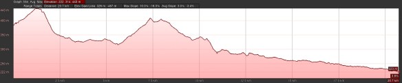
The first 10km was very nice but once we hit the rail trail, it soon got boring and painful; we missed a turn off around 5km from Apt and we really should not have missed it; 10km on a blacktop bicycle path was too, too much; Apt is cool old town worth exploring
Day 21 – Apt to Coustellet Distance: 25.3km Time: 7.25hrs (5.75hrs moving)
Elevation gain: 172m Elevation loss: 287m
We did our best to avoid the rail trail and liked our route but it was difficult and again; we missed a turn where we could have avoided 3+km section of the bike trail – stay awake and keep your eyes open; avoid the L’impréau café / bar in Beaumettes
Day 22 – Coustellet to Eygalières Distance: 26.6km Time: 7.25hrs (6.0hrs moving)
Elevation gain: 132m Elevation loss: 125m
Still more rail trails but only 2km; but all the rest was on straight blacktop roads anyway; there is a new marked trail after crossing the Durance on a quiet road rather than along the river and this was the best part of the trail; Cavaillons would have hotels and possibly hostels; Eygalières is a cool old town but very expensive to stay in
Day 23 – Eygalières to Saint Étienne Distance: 23.8km Time: 7.0hrs (5.5hrs moving)
Elevation gain: 188m Elevation loss: 263m
We followed the GR markings until Saint-Rémy-de Provence where we walked into the town for food, Saint- Rémy is a very cool town, particularly if you like Vincent Van Gogh; very enjoyable trails today and another Roman bridge; Saint- Rémy was a Via Domitia town and there are artifacts around to prove it; from Saint- Rémy we had to go off the GR route to take quiet roads and a nice canal trail to Saint Étienne; the forested mountain tracks would have been nice but too long
Day 24 – Saint-Étienne to Arles Distance: 23.8km Time: 7.25hrs (5.5hrs moving)
Elevation gain: 252m Elevation loss: 290m
We took the GR trails through the forested mountain that we missed yesterday on 6km of great trails; the farm roads to Fontvielle were a little boring but okay; Fontvielle was worth a little extra exploring; the road from Fontvielle to the edge of Arles was boring and the road into Arles was disappointing until we got to the old city walls where it was really nice
Day 25 – Arles to Saint-Gilles Distance: 22.0km Time: 6.25hrs (5.0hrs moving)
Elevation gain: 71m Elevation loss: 69m

We took the Petit Rhône River levee walk most of the way to Saint-Gilles; that’s an alternative route but greatly preferred by most pilgrims; don’t expect to see much of the river but the trail on the levee is awesome; flat as can be except the short steep climb into Saint-Gilles; hostel just on your left as you stand on the steps with your back to the church
Day 26 – Saint-Gilles to Vauvert Distance: 20.6km Time: 5.5hrs (4.75hrs moving)
Elevation gain: 215m Elevation loss: 177m
I liked our walk but I don’t know where the official route was; there were too many options; flat, quiet farm roads and tracks to the southern tip of Generac; nicest trails just south of Generac; more roads around farms to Beauvoisin where we had trouble finding any food; more quiet roads to Vauvert; a very nice short walk
Day 27 – Vauvert to Saint-Christol Distance: 23.6km Time: 7.25hrs (5.75hrs moving)
Elevation gain: 205m Elevation loss: 183m

Mostly on Camino markings on quiet vineyard roads; we ignored a new Camino detour, not knowing where it lead to as we were happy with the old route through a commercial farm; food (and beds) available in Gallargues-le-Montueux; dinner options only “in season” in Saint-Christol; many pilgrims take a more direct to Montpellier after Villetelle but we didn’t; we did, however, take a fairly direct route through Saint-Series to Saint-Christol including some very nice hilly trails; for the last kilometer, walk in the vineyards, not the road
Day 28 – Saint-Christol to Montpellier Distance: 27.0km (to church) Time: 7.75hrs (6.5hrs moving)
Elevation gain: 266m Elevation loss: 291m
It was very long and hot for us so we were very happy about it being the last day; off-Camino trail to Saint-Geniès-des-Mourgues on excellent tracks rather than Camino roads; back on the Camino way from there; great 2km trail after Mas de Rou winery but too short; by Vendargues, we just prayed to be finished; 13km of city walking into Montpellier; Ugh
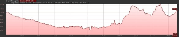
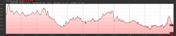
Totals – 29 days walking Distance: 656.5km Time: 193.5hrs (151.5 moving)
Elevation gain: 8,206m Elevation loss: 8,252m

Great post, very helpful for those interested in this route, thanks! I love reading your Camino experience! Where to next?
LikeLiked by 1 person
Thanks much for the feedback. The current plan for the next walk is from Rome to Brindisi in the Spring. One language to get used to per Camino is enough!
LikeLike
Greetings from Apt on the 653D – wanted to say how much I’ve enjoyed your blog and its handy hints (the gorge of san gervasio coming out of cesare Torinese was a winner). Also i hadn’t used maps.me before – thanks to you I am now a convert! From another post I see you are walking the Frances now (or soon) – I guess I am about 40 days behind you and will prob split off from Leon and do the Primitivo. Well, many thanks. Buen Camino. Nick
LikeLiked by 1 person
That’s fantastic that you are walking that route. It’s a wonderful Camino, although lonely at times. I’m also glad my notes helped in any way. Yes, today is day 10 out of Saint-Jean-Pied-de-Port and it’s been a doozy of a trip so far. Hail and gale force winds on the Pyrenees and historic rains and floods a couple of days ago. The trails in the mountains were often calf deep in red muddy rivers or covered in boot high mud. We had a great time but a lot of pilgrims took taxis or busses from Azauieta or Villamayor. It was crazy. Enjoy your walk. Buen Camino!
LikeLike