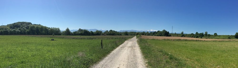
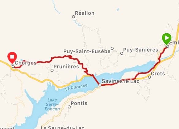
Today’s walk was tough on my feet as most of it was on the road. Don’t blame me though. We did about 30% of Via Do-Smithia and 70% on the Camino trail and my section was mostly off-road and lovely trails. The Via Domitia was almost exclusively on small quiet roads but roads none the less.
We started off today on the wrong foot because I didn’t want to have anything to do with the hotel’s restaurant. We refused their breakfast, knowing full well that a cafe would be open nearby. Somewhere. Ummmm…. anywhere? Well, okay, we couldn’t find one so we set off with empty stomachs for a long day. More importantly, Melanie uses coffee like a Porsche uses petrol. She just goes a lot better with a full tank and she didn’t have any to start the day

Fortunately, just before we crossed the Durance River for the umpteenth time, we found a cafe! Fantastic! They had good coffee and a juice for me but they had nothing to eat out in the open like other cafes. We asked if they have a croissant or something and the woman who ran the place said “of course” but then listed out the ground rules. First, she had only croissants and the “chocolate bread”. Second, it would take her ten minutes to heat them up and third, she would only serve us if we ordered three items, not two, not four, maybe six. We considered waiting for someone else to come in and want a single croissant like a normal person but then I took one for the team and ate two by myself. I’m telling you – the sacrifices I make!
Upon leaving the cafe, we were almost immediately hit with bad news – the bridge was closed for repairs. This could have meant a 7km detour if we didn’t ask for help or, in my case, study an alternate trail the night before. There was a footbridge not too far away that barely shows up on maps but maps.me suggested I use this route last night. We just had a few minutes detour instead and that’s where we started the Via Do-Smithia.
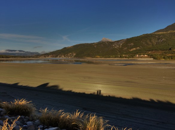
Spot our shadows
Accommodations were a little challenging to find for this section. We could have done an easy route of 10km and stayed in Savines-le-Lac or, altervatively, a tougher 20km route via the 12th century Abbaye-de-Bescodon which would have been cool to see. The problem was that, last night, we couldn’t find anyplace to stay after Savines-le-Lac. My scheduled stop was Montgardin but there didn’t appear to be any good place to stay there. Eventually we found a B&B that was supposedly in a village closer to Savines, Chorges that was decently priced and the location could work for us. If we stayed there though, we could combine the shorter route to Savines with the actual Via Domitia marked trail to Chorges and it was expected to be about 26km with a big hill near the end, so that’s what we did.
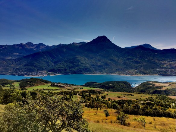
Out of Embrun to the footbridge over La Durance, it was obviously all road or pavement walking. Once over the footbridge though, we headed southwest a half kilometer and started walking on the levee next to La Durance which was now a fairly empty lake rather than a river. I think the river had been dammed further downstream for hydroelectric power and this part of the resulting lake goes fairly dry in the summer. In the springtime, I am guessing that the melting snow from all the nearby mountains goes a good way to filling the lake. This was the best walking trail of the day, considering the gravel and dirt trail as well as the scenery. This trail, and some bush walking for a bit after that got us as far as the stream that comes down the mountain from the Abbey.
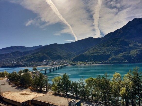

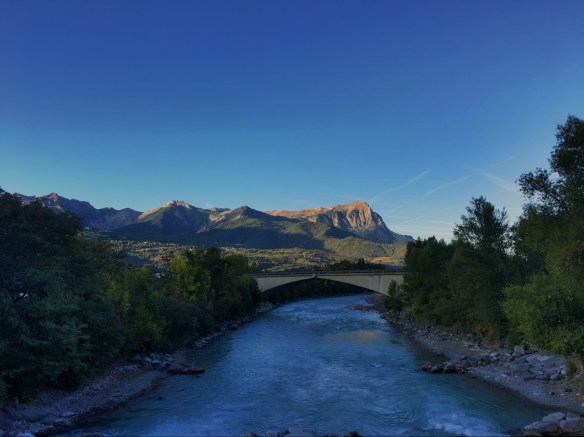
After that, we had about 3km on the dreaded N94 until some quieter side roads saved us. Then we had final crossing of La Durance on this Camino. We’ll miss that river. It did save its best for last though because the bridge was more than a kilometer long over the lake. That is when the fun started.
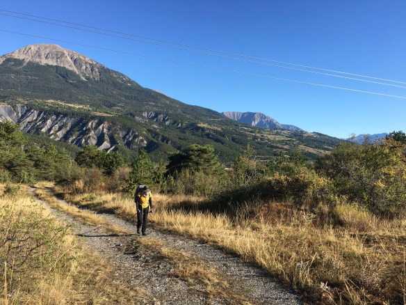
We had a 400m climb to make over 7km up to the village of Saint Apollinaire. That was a slow process and the noonday sun was draining our energy as much as the hill was. Most of that trail was on road but there were a few sections off-road. All we could do was think of the nice sandwich and cold drink that we would have when we reached the village. Sadly, there is not a single store, cafe or bar in the town. We had to press on to Chorges. At least now we were mostly descending but still mostly on road too. I’ll get blisters if I keep that up.
Finally we reached Chorges at 3:15pm. We were instructed to call our host when we arrive and then he (Jacky) would come and fetch us. It turns out that his house is house is 2.4km northwest of town. He actually can pickup people from Montgardin too, since that is just as close but we didn’t know that before. Jacky is a retired teacher and part time gardener with a lovely house. Thankfully, he is also fluent in English
That said, I kept falling asleep as I typed that last paragraph. Please pardon the typos and other errors. I have to get to sleep.
Peace y’all.

What we were planning to do…
…and hat we did…

…and what it meant in climbing [647m elevation gain, 654 loss)

 .
.

I’ve been vicariously following your footsteps as much as can be done with Google Maps Street View. Chorges looks lovely and seems to have an abundance of cafes ;~)
LikeLike